|
Directing evacuations, reducing damage and saving lives in the aftermath of major disasters like wildfires, chemical blazes, or volcanic eruptions will all be improved thanks to a new drone that provides critical air quality data to ground-based emergency services in real-time.
Critical air quality information is needed for deploying emergency services, evacuations and survival in the aftermath of a catastrophic event, such as a volcanic eruption, a wildfire or a chemical plant explosion.
Natural disasters like the infamous eruption of Iceland's Eyjafjallajökull in 2010 can severely impact air quality and safety in the short term and are often outside the reach of fixed monitoring station networks.
Similarly, wildfires, which destroyed 700,000 ha of land in the EU this year according to the European Forest Fire Information Service (EFFIS), and 8.8 million acres caused by 52,699 individual fires in the USA in 2017, were estimated to kill up to 339,000 people worldwide per annum.
Rapid Response Drone
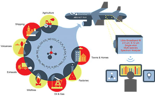
Reaching speeds of up to 120 km per hour and covering an 80 kilometre radius, the drone is fitted with a novel photonic sensor that can simultaneously detect dozens of toxic gasses in an instant.
Flying through some of the toughest environments on earth such as dangerous clouds or poisonous plumes, the FLAIR (or 'Flying ultrA-broadband single-shot Infra-Red Sensor') drone aims to provide real-time air quality data used for quick decision-making during evacuations and the deployment of rapid response emergency services.
|